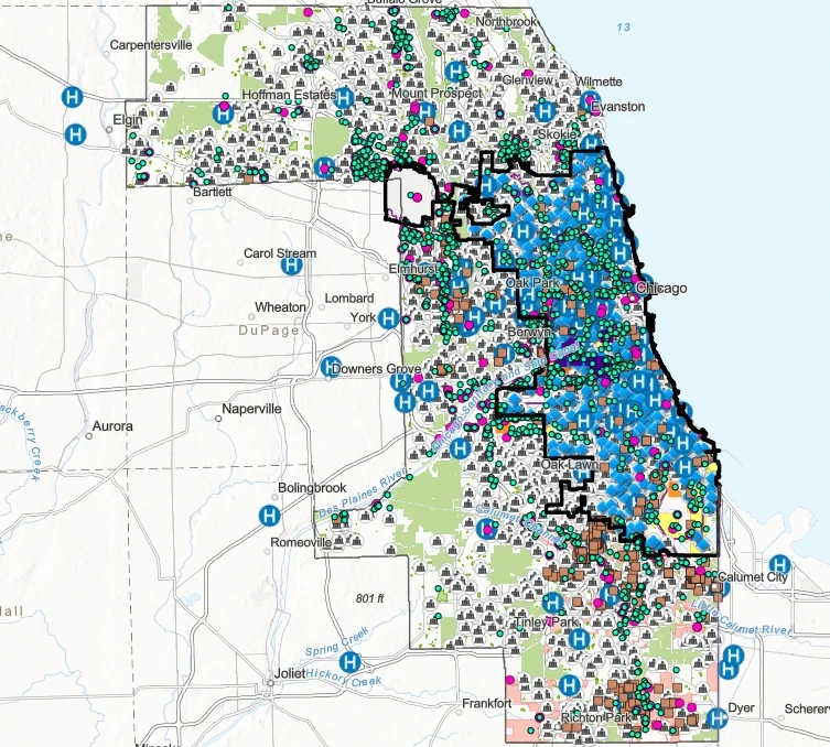
The UIC School of Public Health (UIC-SPH) Emergency Management and Resiliency Planning (EMRP) program, in collaboration with the Electronic Visualization Laboratory (EVL) and subject matter experts, developed a series of Midwest Comprehensive Visualization Dashboards (MCVD) focused on environmental health and justice issues.
The MCVD includes an interactive visualization interface with dynamic maps and supporting documentation detailing data sources, methodology, findings, and resources. The first two versions of MCVD (EJ.1 andEJ.2) identified that several hazardous sources in Chicago were disproportionately concentrated near public schools serving predominantly Latinx student populations.
Building on these findings, the third version of MCVD (EJ.3)utilized a community-based participatory design approach shaped through collaboration with community groups and policymakers. This process focused on creating accessible data visualizations that helped residents understand environmental concerns while providing policymakers with tools to identify and address environmental justice challenges, including industrial impacts such as rail yards in Southwest Chicago.
Through continued stakeholder engagement and support from the UIC Library INDIGO portal, EJ.3 evolved based on community input. The final dashboard serves as an accessible resource to support environmental awareness, advocacy, transparency, and informed decision-making.
The Proximity to Hazards Dashboard provides users with essential geographic information, including Chicago community areas, landmarks, streets, highways, and industrial corridors where a signicant portion of industrial activity occurs.
The interactive interface allowed users to select a location on the map or search for a specific address to better understand nearby environmental conditions. Results displayed information regarding surrounding hazardous sources and key locations of interest.
This version of the PHD included Chicago Public Schools as sensitive community locations and identified several categories of potential environmental hazard sources, including Toxic Release Inventory (TRI) facilities, rail hubs, brownfield sites, and asphalt plants located within the Southwest region of Chicago. Each source category was represented with unique map symbols and an integrated legend, allowing users to easily interpret data, identify environmental concerns, and better understand potential proximity-related impacts within their communities.

TRI facilities were included as documented sources of hazardous emissions. Data from the USEPA TRI Basic Plus Database provided facility locations and information related to reported toxic chemical releases, including emission quantities and potential health concerns.
Major freight railroad hubs were incorporated due to their contribution to particulate matter pollution. Chicago contains eight major freight rail hubs, with six located in the Southwest region of the city. Data was collected from the U.S. Department of Transportation database.
Brownfield locations were included to identify properties where redevelopment may be impacted by the presence or potential presence of hazardous substances, pollutants, or contaminants. The dashboard utilized data from the USEPA’s “Cleanups In My Community” database to evaluate brownfield proximity and density.
Asphalt production and processing facilities were added due to concerns from Southwest Chicago communities regarding their proximity to residential areas. These facilities were identified by name and location to improve public awareness, with ongoing efforts to expand available information for asphalt facilities throughout Chicago.


• Flax-Hatch,J., et al., (2021) MCVD: Environmental justice and neighborhood schools in Chicago, Illinois: Part I. https://doi.org/10.25417/uic.14597814.v3
• Flax-Hatch,J., et al., (2021) MCVD: Environmental justice and neighborhood schools in Chicago, Illinois: Part II. https://doi.org/10.25417/uic.14998152.v1
• J. Flax-Hatch, et al., Identifying Environmental Hazards within Southwest Chicago. UIC-SPH and SEA story map. Original publication date: 20 March 2020. Based on the results presented at the Community Meeting at National Latino Education Institute 01/16/2020. Available at: https://storymaps.arcgis.com/stories/28c9b80be613427fa07f008d72956426
• Flax-Hatch, J., et al., (2021). Visualizing environmental justice issues in urban areas with a community input approach. Spatial Data Science Symposium 2021 Short Paper Proceedings. UC Santa Barbara: Center for Spatial Studies. https://doi.org/10.25436/E2Z30J 5. Agency for Toxic Substances and Disease Registry (2005). TOXICOLOGICAL PROFILE FOR NICKEL. U.S. Department of health and Human Services. Division of Toxicology/Toxicology Information Branch. Accessible at: https://www.atsdr.cdc.gov/toxprofiles/tp15-p.pdf.
• Arling, G. Purdue University, School of Nursing, College of Health and Human Sciences.
• Cailas, M. D., Flax-Hatch, J., and Shao, Y. Environmental and Occupational Health Sciences, School of Public Health, University of Illinois Chicago.
• Derrible, S. College of Engineering, Department of Department of Civil, Materials, and Environmental Engineering.
• Miranda, F. College of Engineering, Department of Computer Science, University of Illinois Chicago.
• Sambanis A. Health Policy and Administration, School of Public Health, University of Illinois Chicago.
• Siciliano, M. College of Urban Planning and Public Affairs, Department of Public Administration. © 2021 J. Flax-Hatch and M. D. Cailas EMRP-EVL MCVD EJ.312.10.21 Page 7 of 8
The authors would like to acknowledge the participation of the Southwest Environmental Alliance group for making the community-based participatory design approach feasible. Many thanks to the Director of Marketing and Communication, Mr. Rob Schroeder of the UIC-SPH, for his efforts to make this work known to the public. The authors would also like to express their gratitude to Ms. Janet Swatscheno of the University of Illinois at Chicago Library for assisting us with the electronic filing and dissemination of this dashboard.
This work (MCVD EJ.3 or PHD) is provided "as is" without any kind of warranty or conditions of any kind, either express or implied, including, without limitation, any warranties or conditions of title, non-infringement, or fitness for a particular purpose. End-users are solely responsible for determining the appropriateness of using or redistributing the work (PHD or MCVD EJ.3) and assume any risks associated with their exercise of permissions. In no event shall UIC, the creators, or copyright holders be liable for any claim, damages, or other liability arising out of or in connection with this work.
This is an open-access document distributed under the terms of the Creative Commons Organization: Attribution, Non-Commercial, No Derivatives 4.0 Unported International License (CC BY-NC-ND 4.0). This license allows re-use to copy and distribute the material in any medium or format in unadopted form only, for non-commercial purposes, and only so long as the corresponding author is notified and the source is credited (see citation). Derivatives of this work are not permitted.